Real Estate Vilcabamba - Rio Uchima - Quintas details

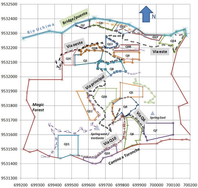
Above is a site plan. The top boundary on
the chart (north) is the Uchima river and the bottom boundary (south) is the "Camino
a Toronche" a trail used to connect the village of Sacapo with surrounding farms.
Each square is 100m by 100m which is 1 hectare or 2.5 acre. The units on the axis
are meters (U.T.M. coordinates, GPS system Datum PSAD 56 zone 56).
The black dotted line is the main road starting at the bridge by the river and going
all the way up to Quinta 4 where the tapia house is located. From Q4 the road branches
off into 2 directions: to the west to give access to Q10 and Q11 and to the east
to give access to Q6 and Q7. The lighter color dotted lines are trails. For clarity,
not all trails are shown on this map.
There is ample space on the property to accommodate 17 quintas in a way that guarantees
great privacy. With the exception of Q1 and Q2, Q3 and Q3b (if purchased separately)
and Q4 and 5, no quinta has a boundary with another quinta. In other words, there
is always a buffer zone between the quintas to improve privacy and allow the free
flow of people (and grazing animals if desired) between the parcels.
If you count up the quintas on the map, you will see more than 17. That is
to provide a greater range of choices for prospective purchasers. We may add
more as the need arises, and as possible, without compromising the privacy of any
of the others. However, only 17 will be sold; when the 17th is purchased,
the remaining unsold ones will all become part of the common land. From then
on, quintas may change hands, but no more will be added.
All quintas have road access. The road is
unsealed (most roads are in Ecuador) and of good quality using surface material
available locally in San Pedro and on the property itself (in Spanish called "lastre").
This material is better than gravel as it does not wash away and with rain and time
turns into a very hard surface, almost like a sealed road. The road from San Pedro
to Sacapo for example is of similar construction whereas roads to other areas around
Vilcabamba are not and the difference in comfort is striking (e.g. the road to San
Jose or the road to Chaupi which are both terrible).
The entrance to the property is via a newly built concrete bridge on the river ("Bridge"
on the top of the picture, the river is the northern boundary). From the bridge,
a private road (marked "main road") goes to the top of the property. The elevation
of the river is approximately 1630 m above sea level whereas the top of the property
is at approximately 1970 m of elevation.
From the main road, a secondary private road goes to to Q17, another one to Q14
and another one to Q3C. For more information on the roads see our infrastructure section.
For more details on each quinta select the "Quintas" tab above
or click